ISSUE 5. Urban modeling and simulation: tools for our cities yet to be discovered. By Javier Sandoval
UrbanLab
www.urbanlab.city
A few years ago, as head of the urban planning department of my city, I was coordinating an urban planning instrument that had the particularity of containing an agricultural valley and, similar to other parts of the world, was facing processes of uncontrolled urbanization. Given the imminent loss of this productive land, I had the idea of proposing to the municipal administration the implementation of a constructive moratorium in this area, at the same time the elaboration of this planning instrument was being conducted, this instrument would regulate its occupation. Apparently, the strategy was totally predictable: not allowing growth would be equivalent to not having more constructions, or would it? At the same time, my department was favored with a positive response from Kent State University to provide a source code of an urban simulator that had been designed for this geographic area called Urban Growth Simulator. With a simple interface and without the need to install any software, you could experiment from any Internet browser with different areas in the state of Ohio and predict what their urban future could be. With this tool at hand, I set out to answer this question: what could happen in the agricultural valley if we applied the moratorium?
Without any expectations, I created two scenarios, one without any intervention and another prohibiting any urbanization in an agricultural area. In the first result, housing zones emerged along the road, mixed areas directly adjacent to a coastal lagoon, industrial areas in the heart of the valley, and other uses that mimicked what was happening at the time. No surprises there. In the forbidding scenario, the agricultural areas were preserved, and the valley maintained its main characteristics. No surprises there either. Like any simulation, the scenarios were executed several times, but the results remained more or less the same, as long as they were observed in the same fashion. Because I was focusing my attention on the results on the valley, I had not noticed what was happening again and again elsewhere: like a "pressure cooker", real estate interests could no longer grow where they did before, now they were looking for new places of investment and were finding them along a peninsula adjacent to the valley (Fig. 1). This site had spectacular views of the sea, but its urbanization would not be the most convenient because it was crossed by geological faults. By wanting to control one problem, another could be generated. The message of the simulator was clear in demonstrating that applying public policies on one part of the territory could have unintended consequences in another, which forced me from that moment on to always contextualize any regulation or urbanization work with its environment. And this, thanks to the use of a simulator.
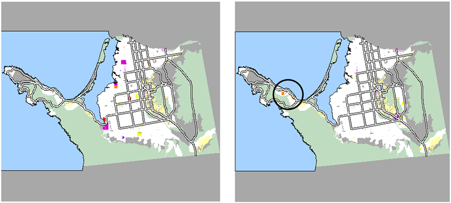
Fig. 1 Left: Occupation resulting from trending scenario. Right: Scenario of moratorium of urbanization on the valley of Maneadero where the urbanization of the peninsula of Punta Banda is accelerated (in the circle, new tourist developments).
But how can a computer program know the future of a territory? how does it do? Let's start by defining that a model is a simplified representation of reality, and when experiments are conducted with a model, we say that a simulation is being performed. The basic unit of these representations are called agents, understood literally as defined by philosophy: entities capable of acting in the world. In the context of agent-based urban models, these can represent cars, people, land uses, infrastructure, equipment, buildings, or any other urban entity that can make a decision or react to what's going on around them. To explain it better, agent-based models can be understood as theater plays without a script. There are actors (agents) who operate on a stage (environment), and who interact with each other (interactions). Unlike a traditional play, there is no script for the actors to follow but objectives to be achieved, and for which they are granted autonomy to decide how to achieve those according to what they perceive and learn from the other agents as well as the environment in which they are immersed. In this way, the viewer will never know in advance what the development of the work will be and even when to consider when it ends. Surely, as it happens in the practice of simulations, you will be tempted to let the work continue in front of an unexpected and interesting plot that arises before your eyes. Who would like to interrupt something that catches so much attention? Something similar happens when experiments are carried out with an agent-based urban model: once the agents, their environment and interactions are designed, they are left to act freely through the virtual territory while the modeler observes the development of that particular narrative. This will be repeated many times. We will find that each ending varies due to the simulation randomness, and because the agents learn from their experiences if they are programmed to do so. Moreover, it is possible that the modeler attests to the emergence of new properties of the urban system, different from the individual properties of any agent that composes it, and that in the context of complex systems this is called an emergent process.
Although the reasons for the use of simulation are varied, they can be located in the spectrum contained between two extremes, explore and forecast. The first intention is to learn urban concepts and theories through generic territories. This approach has great potential in urban study studios where the student can understand through direct experimentation concepts such as density, compatibility of land uses and consumption of the territory. At this end we can also fit games that have cemented their own category called "city builders" such as the long-lived Simcity or the most recent Cities Skylines, both recommended for those who want to play to build and manage a city and understand the city where they live. At the other extreme is forecasting (I avoid using the word "predict" because of the expectations it generates) which is useful for the design and testing of territorial public policies before implementing them in the real world, or to anticipate regulatorily possible future scenarios of adverse urbanization. Here the territories are not generic, they represent real cities. Some time ago I carried out some simulations to know the possible results of applying an urban program that was still in the design phase. These simulations demonstrated the places with the most possibilities for urbanization regardless of their compliance with urban regulations. A year later I was getting a call from the mayor informing me of a company interest in building in one of the places predicted by the simulator. Had we acted in advance as expected, we would have been able to intervene more effectively in this situation (Fig. 2), particularly since the proposal was to urbanize an important natural runoff.
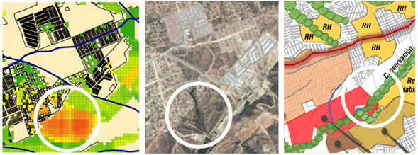
Fig. 2 The circles show the same simulated location (left), real (center) and projected location (right), which shows as a red polygon an intended housing development.
Fortunately, the software, computer equipment and databases necessary to perform urban simulations to replicate these experiences in the work or research environment are becoming more accessible. And although the learning curve may be high at first, this should not be a major impediment to the educational and public policy benefits that could be obtained, particularly for Latin American cities in constant processes of expansion. For those who want to learn how to use these tools, a good starting point is to familiarize themselves with a programming environment for agent-based models such as Netlogo(https://ccl.northwestern.edu/netlogo)which is free and is used by hundreds of students and researchers in various research centers. In formative aspects the options are few and in Spanish practically null outside ofother academic institutions. In terms of reading there is the downloadable book Introduction to the Netlogo Language and Agent-Based Programming by Francisco Quesada Chaverri(http://franciscoquesada.com/index.php/netlogo) who is thanked for his selfless writing. Additionally there is the site www.urbanlab.city where you can take free introductory webinars from its video library or enroll in the urban simulation courses that are regularly taught on that site.
About the author:
Javier Sandoval
Javier is an urban systems modeler with more than 15 years of professional experience at the intersection of urban research and public policy. He is the founder of the urban laboratory and public policies UrbanLab, promoter of the teaching and use of Agent-Based Urban Simulation for the advancement of territorial knowledge and the creation of public policies applying them in the eminently practical context of local governments. He is the creator of the online open school of Agent-Based Urban Simulation.
He worked for more than 14 years at the Ensenada Municipal Research and Planning Institute, of which he was director, during which time he specialized in Planning Instruments with a Human Rights Approach, Planning of Wine Zones and in the preparation and evaluation of Studies of Urban Impact. He has complementary education in urban design, complex systems, agent-based modeling, and data visualization. His professional activity has included academic work in public and private universities as professor and guest speaker for more than 15 years and as coordinator of professional courses in the evaluation of urban impact studies, planning instruments and the application of urban simulation. practice. He is an External Training Agent registered with the Ministry of Labor and Social Welfare of the federal government of Mexico.